BX10 to Riverdale: Key to Understanding NYC's Problems
Boarding an MTA bus in New York City rarely feels like a philosophical exercise, but routes that cross distinct socioeconomic boundaries have a way of telling the city’s unfiltered story. The route running from the working-class streets of Norwood and Kingsbridge up into the leafy, historic mansions of the northwest Bronx prompts an intriguing urbanist question: BX10 to Riverdale: Is This the Key to Understanding NYC's Problems? In many ways, the answer is yes. In under an hour, this single cross-borough bus line cuts through the fractures defining 21st-century New York: transit access disparities, exclusionary zoning, severe wealth inequality, and the daily friction between service workers and the enclaves they maintain.

The Route: From Dense Bronx Corridors to Suburban Bluffs
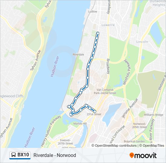
The Bx10 begins its journey in Norwood, near the end of the D train line, winding past institutions like Montefiore Medical Center, Lehman College, and Bronx High School of Science. Here, the sidewalks hum with foot traffic, street vendors, and high-density apartment blocks home to working-class Latino, Black, and immigrant families.
As the bus crosses the Broadway corridor near the West 231st Street 1 train station, the urban fabric shifts dramatically. It grinds through Kingsbridge commercial congestion before climbing the steep bluffs of Spuyten Duyvil and entering Riverdale. Towering apartment complexes give way first to mid-century co-ops along Kappock Street, then to tree-shaded boulevards, mid-century modern single-family estates, and private estates in Fieldston. By the time the bus reaches its northern turnaround near the College of Mount Saint Vincent at West 263rd Street, the surroundings feel less like the Bronx and more like an affluent Westchester suburb.
BX10 to Riverdale: Is This the Key to Understanding NYC's Problems?
To view the Bx10 merely as a commuter line misses its broader sociological significance. The route functions as a physical cross-section of New York’s most pressing systemic contradictions.
1. The Labor Divide on Display
Morning commutes on the Bx10 run in stark opposition to the typical outward flow toward Midtown Manhattan. While white-collar Riverdale residents head down to the Metro-North station or board express buses like the BxM1 and BxM2 directly to Manhattan, the northbound Bx10 carries thousands of essential workers into Riverdale. These riders are:
- Healthcare workers and home health aides commuting to senior living communities, nursing homes like the Hebrew Home at Riverdale, and private residences.
- Campus and facility staff serving prestigious private academies, including Riverdale Country School, Horace Mann, and Fieldston, alongside Manhattan College.
- Domestic, landscaping, and construction workers keeping the enclave’s multi-million-dollar estates running.
This dynamic highlights New York’s stark two-tier reality: low-wage workers endure lengthy multi-leg commutes on local buses to serve affluent communities where they could never afford to live.
2. The Failure of Multi-Tier Transit Integration
Riverdale boasts a Metro-North Hudson Line station that can whisk passengers to Grand Central Terminal in under 30 minutes. Yet for most daily commuters along the Bx10 corridor, that rail option remains financially or logistically inaccessible. Historically, high commuter rail fares created an economic wall between the rapid commuter rail and the local bus system.
While the MTA’s CityTicket program has reduced off-peak commuter rail fares, full fare integration with free bus-to-rail transfers remains unrealized. As a result, riders dependent on the Bx10 are forced to rely on slower local buses that regularly get trapped in bottlenecks at West 230th and 231st Streets, while higher-income residents bypass the street congestion entirely via commuter rail or personal vehicles.

Zoning, Preservation, and the Citywide Housing Crisis
New York City is grappling with a severe housing shortage, with citywide vacancy rates hovering below 1.5%. Yet looking out the window of a Bx10 bus reveals vast expanses of low-density land within city borders.
Riverdale features some of the most restrictive zoning in New York City. The Special Natural Area District (SNAD) designation, implemented in the 1970s to preserve steep topography, mature tree canopies, and aquatic environments, has also functioned as an effective barrier against new multi-family housing development. Adjacent Fieldston is an officially designated historic district with private, privately maintained streets.
The contrast along the Bx10 route highlights the city’s geographic double standard for housing growth:
- High-density rezoning is frequently concentrated in lower-income areas of the South and Central Bronx, overburdening existing infrastructure.
- Preservationist protections shelter high-opportunity, transit-accessible neighborhoods in the Northwest Bronx from absorbing their fair share of new affordable homes.
Bus Speeds, Congestion, and Transit Priority Resistance
The MTA’s Bronx Bus Network Redesign, implemented in June 2022, sought to modernize routes across the borough to speed up transit. Yet outer-borough routes like the Bx10 continually run up against a persistent roadblock: street space allocation.
The stretch of the Bx10 that passes Broadway, Kingsbridge Avenue, and the commercial strip of Johnson Avenue frequently crawls at single-digit speeds. Proposals for dedicated bus lanes, transit signal priority, or curbside loading zones regularly meet stiff pushback from local merchant groups and car-owning residents concerned about lost parking. This dynamic plays out across all five boroughs, where the mobility needs of thousands of bus riders are consistently compromised to protect parking spaces for personal vehicles.
What the Bx10 Teaches Us About Fixing New York
If the Bx10 mirrors the city’s core problems, it also points toward obvious policy solutions. Fixing the fractures visible along this six-mile stretch requires addressing the structural barriers that keep urban neighborhoods isolated from one another:
- Accelerate Bus Priority Infrastructure: Installing dedicated bus lanes and automated camera enforcement along pinch points on West 231st Street and Riverdale Avenue would dramatically speed up commutes for working-class transit riders.
- True Regional Fare Integration: Integrating Metro-North stations like Riverdale and Spuyten Duyvil into the standard OMNY transit fare system with free bus transfers would unlock rapid regional transit for everyone along the Bx10 corridor.
- Equitable Land Use and Infill Housing: Reassessing restrictive low-density zoning in high-resource neighborhoods would allow modest, transit-oriented development—such as accessory dwelling units (ADUs) and low-rise apartments near commercial corridors—without destroying the natural landscape.
A Six-Mile Microcosm of New York City
A ride on the Bx10 is never just a trip between two points in the Bronx. It is an instructive journey through the physical and economic boundaries of New York City. From the crowded bodegas of Kingsbridge to the gated drives of Riverdale, the Bx10 illustrates how transit design, land use, and class barriers converge every single day. If urban planners and policymakers want to solve New York’s crisis of affordability and equity, they don’t need another academic study—they simply need to take a ride on the Bx10.