High Tide for Plymouth: Daily Guide & Tidal Times
Whether you are launching a kayak from Firestone Bay, casting a sea-fishing line off Mount Batten Breakwater, or securing a yacht in Sutton Harbour, knowing the exact timing and height of the high tide for Plymouth is essential. Plymouth Sound and its interconnected estuaries experience dynamic, semi-diurnal tidal shifts that dictate navigation, beach access, and coastal safety every single day.

Because tides change continuously based on lunar cycles and meteorological conditions, static times quickly become obsolete. This guide explains how Plymouth’s tidal system functions, where to check daily live data, how local geography impacts water movement, and what you must watch out for when planning your time on the water.
Understanding Plymouth’s Tidal Pattern
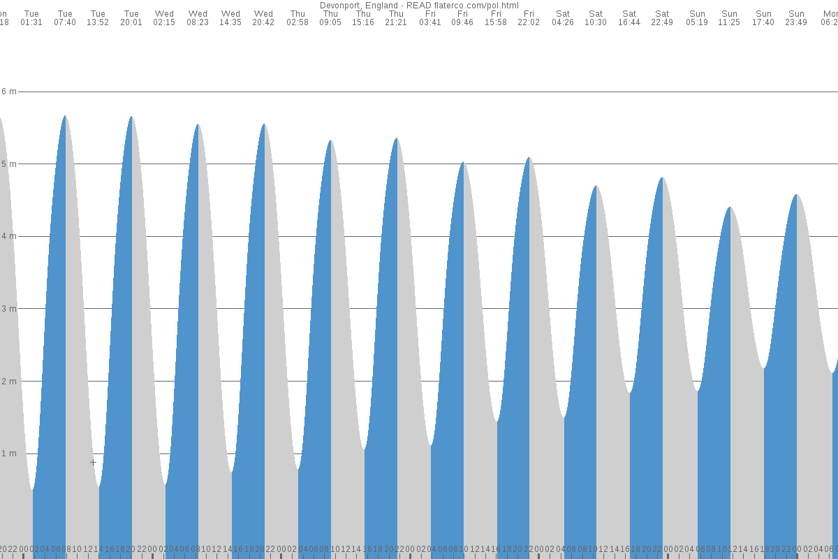
Plymouth experiences a semi-diurnal tidal cycle, meaning the area sees two high tides and two low tides roughly every 24 hours and 50 minutes. The interval between a high tide and the subsequent low tide is typically around 6 hours and 12 minutes.
The tidal range—the vertical difference between low and high water—varies substantially across the lunar month:
- Spring Tides: Occurring shortly after a new or full moon, spring tides generate Plymouth’s highest high waters and lowest low waters. At Devonport, Mean High Water Springs (MHWS) reaches roughly 5.5 metres above Chart Datum, with extreme equinoctial springs occasionally topping 5.8 metres.
- Neap Tides: Around the first and third quarters of the moon, the sun and moon exert opposing gravitational forces. Mean High Water Neaps (MHWN) in Plymouth levels out at approximately 4.4 metres, with significantly less water movement and slacker tidal currents.
How to Check the High Tide for Plymouth Today
Tide tables use specific observation stations to ensure accuracy. For Plymouth, the primary reference port is Devonport, though water height along Plymouth Sound, Cawsand Bay, and the River Tamar tracks very closely with this baseline.
When consulting live tables, always confirm three critical details:
- Time Zone (BST vs. GMT/UTC): Many official hydrographic charts and navigational tables record tide times in Greenwich Mean Time (UTC). If you are visiting between late March and late October, you must add one hour to account for British Summer Time (BST).
- Reference Station: Verify whether your source calculates from Devonport, Plymouth Sound, or Cattewater. For general recreational use, Devonport and Plymouth Sound tables differ by only a few minutes.
- Tidal Height: Take note of the predicted height in metres. A 4.2-metre high tide leaves much more beach exposed than a 5.6-metre spring tide, fundamentally changing water depth in shallow coves.
Reliable daily tidal forecasts can be obtained directly from the King’s Harbour Master (KHM) Plymouth, the UK Hydrographic Office (Admiralty EasyTide), the National Oceanography Centre, and the Met Office marine forecast.
Local Landmarks and High Tide Dynamics
Plymouth’s varied shoreline means high water affects different areas in distinct ways. Knowing these local quirks can make or break your day out.
Sutton Harbour and the Barbican
Sutton Harbour relies on an automated lock system to maintain water depth for commercial fishing vessels and leisure craft inside the marina. Around high water spring tides, the lock gates may open for 'free flow,' allowing boats to transit freely. However, during particularly extreme spring high tides paired with southerly surges, the lock gates close to act as a flood barrier, protecting the historic Barbican from rising sea levels.
Devil's Point and the Tamar Entrance
The channel between Devil’s Point and Mount Edgcumbe squeezes the entire tidal volume of the Tamar and Lynher rivers through a narrow neck into Plymouth Sound. As the tide rushes toward high water, and especially during the ebb, currents here can exceed 4 knots. The resulting eddies and submerged shelves make this stretch treacherous for swimmers and small, unpowered watercraft.
The Hoe Foreshore and Tinside
At low water, rocky platforms and shingle pockets emerge below Plymouth Hoe. As high water approaches, these platforms submerge completely, leaving water lapping against sea walls and the outer edge of Tinside Lido. Swimmers entering off the Hoe transit steps should be mindful of the reduced exit points at peak water.
Drake’s Island
The Bridge—a submerged reef running from Mount Edgcumbe to Drake’s Island—dries out significantly at low water springs. At high tide, it becomes concealed beneath several metres of water, creating an invisible navigational hazard marked by navigational buoys that shallow-draft vessels must observe carefully.
Crucial Safety Advice for Plymouth Waters
Tidal movements along the South West coast are powerful. Whether you are walking coastal trails or venturing out on a paddleboard, follow these maritime precautions:
- Beware of Cut-Off Risks: Coves around Jennycliff, Bovisand, and Kingsand diminish rapidly during a rising tide. Walkers exploring rocky outcrops can find their retreat cut off by water up to two hours before peak high tide.
- Account for Atmospheric Surges: Low atmospheric pressure combined with sustained south-westerly or southerly gales can force extra water into Plymouth Sound. This creates positive tidal surges, resulting in actual water levels significantly higher than published astronomical predictions.
- Monitor River Flow: If you are boating upstream toward Saltash, Calstock, or the Yealm, remember that river runoff after heavy rain pushes back against an incoming tide, generating choppy conditions where fresh and salt water meet.
- Carry Proper Communication: Always carry a means of calling for help sealed in a waterproof pouch, such as a VHF radio tuned to Channel 16 or a mobile phone. KHM Plymouth monitors VHF Channel 14 for port operations.
Looking for Plymouth, Massachusetts?
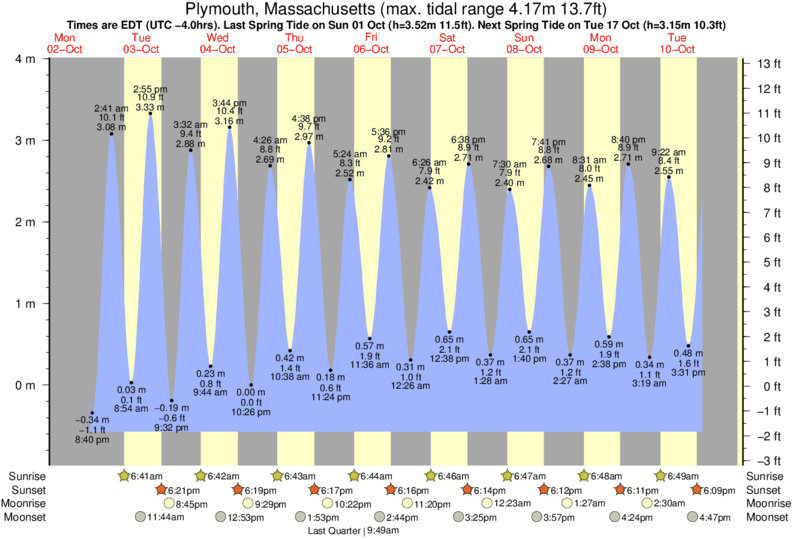
If your search is directed toward Plymouth Harbor across the Atlantic in Massachusetts, USA, keep in mind that tidal metrics differ. Plymouth, MA operates under the National Oceanic and Atmospheric Administration (NOAA station 8443970), featuring a semi-diurnal cycle with an average tidal range of around 9.5 to 10.5 feet (roughly 3 metres). Always ensure your weather app or navigational aid is set to the correct continent before launching.
Summary: Planning Around the Tide
Checking the high tide for Plymouth is an indispensable habit for anyone enjoying Britain’s Ocean City. By checking an Admiralty-standard tide table, adjusting for seasonal time changes, and respecting the strength of currents around headlands like Devil’s Point, you can enjoy Plymouth Sound safely and make the most of its world-class natural harbour.