Is Bangladesh in India? Facts, Map, & History
A common question among travelers, students, and curious observers is: is Bangladesh in India? The short answer is an unequivocal no. Bangladesh is an independent, sovereign country located in South Asia. It is not an Indian state, province, or territory.
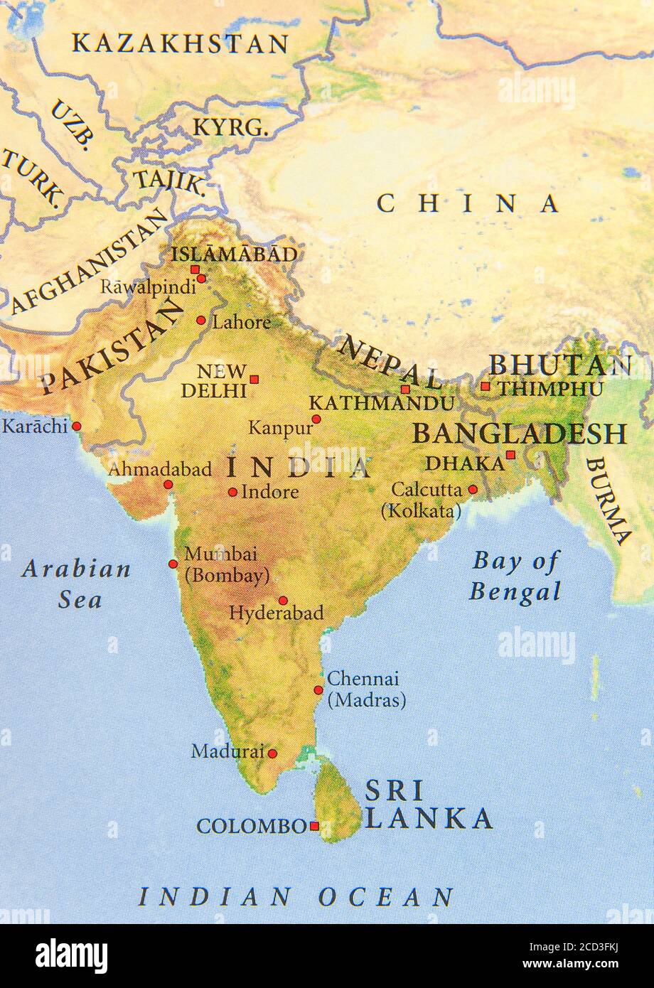
However, the confusion is understandable. Bangladesh and India share a land border spanning over 4,000 kilometers, have deeply intertwined histories, and share broad cultural and linguistic traditions. Furthermore, India contains an official state called West Bengal, which shares a language and heritage with Bangladesh. To understand why Bangladesh is a distinct country today, it helps to examine its geography, its political borders, and the dramatic historical events that shaped South Asia over the past century.
Is Bangladesh in India? The Direct Answer
Bangladesh is a distinct nation with its own government, legal system, military, currency, constitution, and seat at the United Nations. Its official name is the People's Republic of Bangladesh. Its capital is Dhaka, whereas the capital of India is New Delhi.
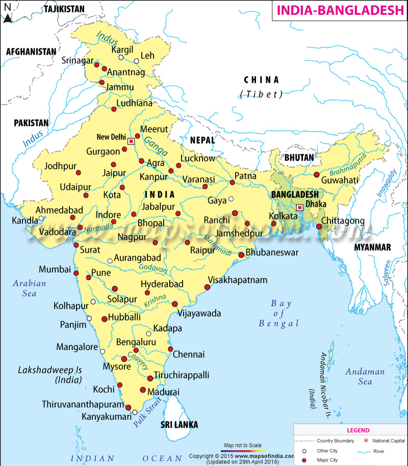
While India completely wraps around Bangladesh on its west, north, and east, Bangladesh maintains full political autonomy. Crossing from India into Bangladesh requires a valid passport, an international visa, and clearance through formal border immigration checkpoints.
Bangladesh vs. West Bengal: Understanding the Confusion
Much of the geographic confusion stems from the term "Bengal." Historically, the broader Bengal region encompassed both present-day Bangladesh and the Indian state of West Bengal.
Today, these two entities exist on opposite sides of an international border:
- Bangladesh: A sovereign country home to roughly 170 million people. The majority of the population is Muslim, with a notable Hindu minority. The national language is Bengali (Bangla).
- West Bengal: An administrative state within the Republic of India. Its capital is Kolkata (formerly Calcutta). The majority of the population is Hindu, alongside a sizable Muslim minority, and the official language is also Bengali.
Because people in both regions speak Bengali, enjoy similar cuisine (such as freshwater fish and mustard-infused curries), and celebrate shared literary icons like Nobel laureate Rabindranath Tagore, outsiders often assume they belong to the same country. In reality, they are two halves of an ethno-linguistic region divided by 20th-century geopolitical realignments.
Historical Timeline: How Bangladesh Became Independent
To grasp why Bangladesh is separate from India, one must look at the key moments of 20th-century South Asian history. Bangladesh’s path to sovereignty involved two major partitions.
1. The British Colonial Era (Before 1947)
Until 1947, both present-day India and Bangladesh were part of the British Indian Empire. During this colonial period, the British administered the region as the Bengal Presidency. In 1905, the British viceroy Lord Curzon attempted to partition Bengal into eastern and western zones along religious lines, but intense public pushback led to its reunification in 1911.
2. The 1947 Partition of India
When the British departed South Asia in August 1947, the subcontinent was divided along religious majorities into two independent dominions: India (with a Hindu majority) and Pakistan (with a Muslim majority). Because Muslims were concentrated in the northwest and the northeast, Pakistan was created as a geographically bifurcated nation:
- West Pakistan: Located along the Indus River basin (present-day Pakistan).
- East Pakistan: Located in the eastern Ganges-Brahmaputra delta (present-day Bangladesh).
At this point, Bangladesh was not part of India; it was known as East Pakistan, separated from West Pakistan by more than 1,000 miles of Indian territory.
3. The 1971 Liberation War
Despite sharing a common religion, East and West Pakistan were culturally, linguistically, and economically distinct. The central government based in West Pakistan systematically marginalized East Pakistan, attempting to impose Urdu as the sole national language and denying the Bengali majority fair political representation.
Tensions boiled over in March 1971 when the Pakistani military launched a brutal crackdown in East Pakistan. This sparked the Bangladesh Liberation War. Following months of guerrilla conflict and the eventual military intervention of India in December 1971, Pakistani forces surrendered. Bangladesh emerged as a free, independent republic on December 16, 1971.
Geography: Where Does Bangladesh Sit on the Map?
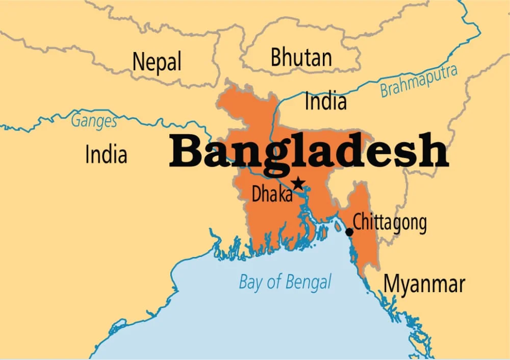
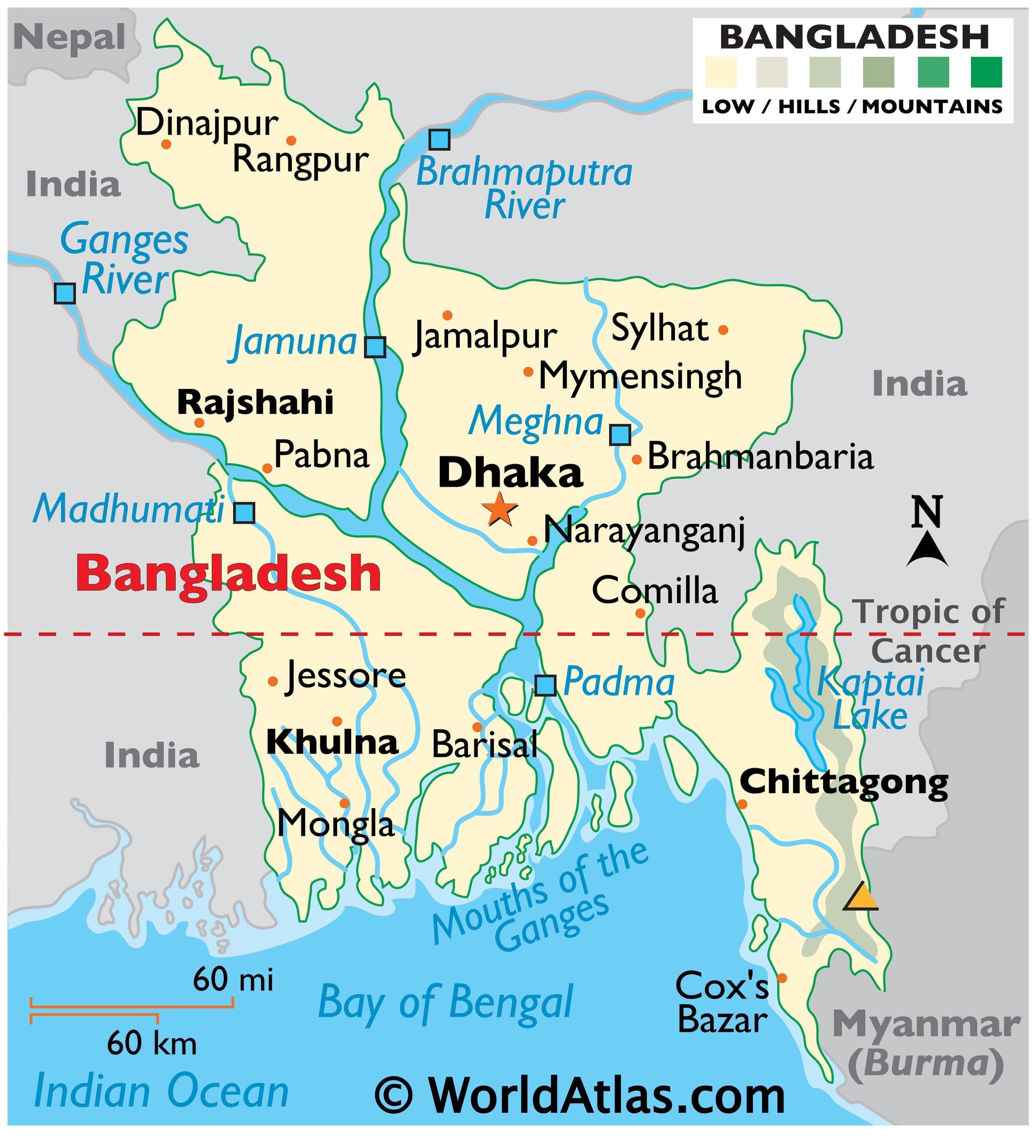
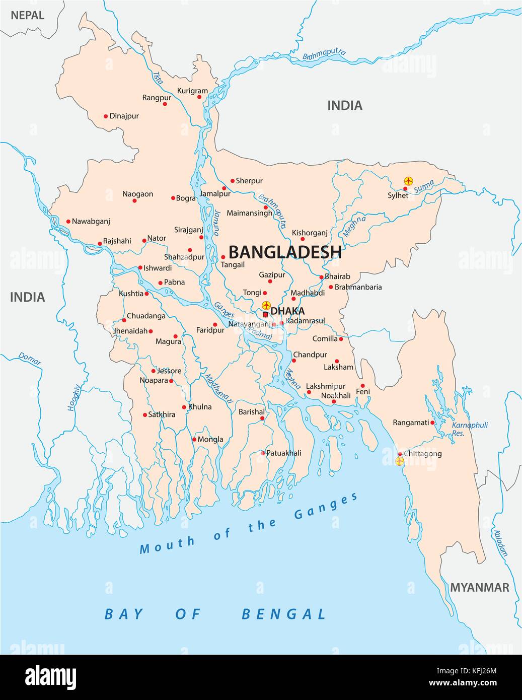
Bangladesh occupies the low-lying, fertile Ganges-Brahmaputra Delta in South Asia. It is bordered almost entirely by India, with a small southeastern boundary shared with Myanmar (Burma) and the Bay of Bengal anchoring its southern coast.
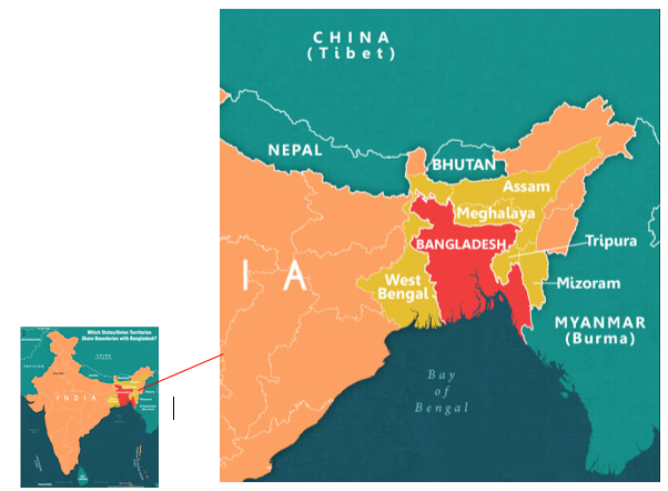
The border between India and Bangladesh measures roughly 4,156 kilometers (2,582 miles), making it the fifth-longest land border in the world. Bangladesh shares boundaries with five distinct Indian states:
- West Bengal: Enclosing Bangladesh from the west and north.
- Assam: Sharing borders along the northern and eastern frontiers.
- Meghalaya: Directly north of Bangladesh, dominated by the Shillong Plateau.
- Tripura: Nearly surrounded by Bangladesh on three sides along the eastern flank.
- Mizoram: Bordering southeastern Bangladesh in the hilly frontier zone.
Because Bangladesh is almost completely surrounded by Indian territory on land, casual observers glancing at a world map occasionally mistake it for an Indian enclave. It is, however, an entirely separate nation-state.
India and Bangladesh: A Quick Comparison
Comparing key national indicators illustrates the political and institutional separation between the two nations:
| Feature | Republic of India | People's Republic of Bangladesh |
|---|---|---|
| Status | Federal Republic | Unitary Parliamentary Republic |
| Capital | New Delhi | Dhaka |
| National Currency | Indian Rupee (INR / ₹) | Bangladeshi Taka (BDT / ৳) |
| Official Language(s) | Hindi, English (+ 22 recognized) | Bengali (Bangla) |
| Independence Date | August 15, 1947 | March 26, 1971 (Declared) |
| UN Membership | October 30, 1945 | September 17, 1974 |
Modern Relations Between India and Bangladesh
Today, India and Bangladesh maintain close diplomatic, economic, and strategic ties. India was one of the first countries to recognize Bangladesh’s independence in December 1971, and the two countries cooperate closely on cross-border infrastructure, energy grids, and trade.
In 2015, both nations resolved a long-standing cartographic issue by ratifying the historic Land Boundary Agreement. This swap exchanged dozens of tiny enclaves—isolated pockets of Indian territory inside Bangladesh and vice versa—simplifying the border and providing thousands of residents with formal citizenship choice for the first time.
Despite this cooperation, friction occasionally emerges over cross-border migration, water-sharing treaties for the 54 shared transboundary rivers (most notably the Teesta River), and border security management.
Final Takeaway
Bangladesh is not in India. Although both countries share roots in the historic Indian subcontinent and maintain deep cultural connections across the Bengal frontier, Bangladesh has been a completely independent, self-governing nation since 1971. When you travel to or study Bangladesh, you are engaging with a unique sovereign country with its own rich culture, language, and national identity.