Mastering Geography with a Printable Blank Northeast Map
The northeastern United States packs centuries of history, dense population corridors, and intricate coastlines into a compact land area. Because several of the country's smallest states sit tightly clustered together, students and trivia enthusiasts often struggle to differentiate borders, locate capitals, and identify key waterways. Mastering geography with a printable blank Northeast map is one of the most effective ways to overcome this hurdle. By removing visual crutches like labels and color-coded boundaries, a blank map forces your brain to retrieve spatial data actively, cementing your mental model of the region.

Defining the Northeast: Which States Belong on Your Map?
Before putting pen to paper, it is essential to understand what constitutes the Northeast. While regional definitions can vary slightly depending on the context, the U.S. Census Bureau officially divides the Northeast into two distinct sub-regions comprising nine states:
- New England: Connecticut, Maine, Massachusetts, New Hampshire, Rhode Island, and Vermont.
- The Mid-Atlantic: New Jersey, New York, and Pennsylvania.
Depending on your curriculum or study goals, some maps also incorporate neighboring states from the northern fringe of the South or the eastern edge of the Rust Belt, such as Delaware, Maryland, or West Virginia. For standard academic testing, sticking to the primary nine-state definition provides a clear, manageable starting framework.
The Science of Active Recall in Map Study
Staring at a labeled atlas creates the illusion of competence. When labels are visible, your brain recognizes familiar names—such as Boston, Albany, or Trenton—without having to reconstruct where they sit relative to one another. This passive review rarely leads to long-term retention.
A blank map relies on the testing effect. When you look at an unadorned outline of the coastline from Maine down to New Jersey, your mind must search its memory for the shape of Cape Cod, the northern protrusion of Maine, or the long wedge of Pennsylvania. Making mistakes on a blank map and correcting them immediately creates far stronger neural pathways than re-reading a textbook diagram ten times over.
Mastering Geography with a Printable Blank Northeast Map: A Step-by-Step Study Plan
Approaching a blank outline all at once can feel overwhelming. Break your study sessions into progressive layers to build spatial awareness systematically.
Phase 1: Anchor Points and Boundary Lines
Begin with the states that possess unmistakable silhouettes. Maine is easy to spot as the northeastern-most point, while New York acts as a massive physical barrier connecting the Great Lakes to the Atlantic Ocean. Once these anchors are set, work inward:
- Resolve the Vermont and New Hampshire puzzle: Vermont borders New York on the west; New Hampshire borders Maine on the east. A helpful mnemonic is that Vermont forms a "V" shape (wider at the top), while New Hampshire resembles an upside-down "V" or an "N"-like slant.
- The Southern New England stack: Moving south from Vermont and New Hampshire, locate Massachusetts (notable for the arm of Cape Cod jutting east), followed by tiny Rhode Island tucked into Narragansett Bay, and Connecticut anchoring the southern border against Long Island Sound.
- The Mid-Atlantic base: Pennsylvania sits entirely landlocked from the open Atlantic, bordered by New York to the north and New Jersey hugging its eastern flank along the Delaware River.
Phase 2: Capitals vs. Prominent Metros
A classic pitfall in Northeastern geography is assuming that the largest, most famous city serves as the state capital. Once you can label all nine state borders from memory, mark the actual political centers:
- New York: Albany (not New York City)
- Pennsylvania: Harrisburg (not Philadelphia)
- New Jersey: Trenton (not Newark)
- Maine: Augusta (not Portland)
- New Hampshire: Concord (not Manchester)
- Vermont: Montpelier (not Burlington)
- Massachusetts: Boston (one of the few where the largest metro is also the capital)
- Rhode Island: Providence
- Connecticut: Hartford (not Bridgeport or New Haven)
Phase 3: Topography and Waterways
Video: Northeast Map Video
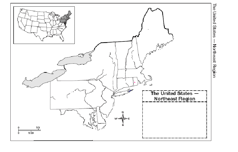
Political borders frequently follow natural contours. To turn your geographical knowledge into an intuitive map, sketch and label major waterways and ranges:
- Rivers: Trace the Hudson River flowing south through New York, the Connecticut River dividing Vermont and New Hampshire before running through Massachusetts and Connecticut, and the Delaware River bordering Pennsylvania and New Jersey.
- Mountains: Lightly shade the Appalachian chain, including the Green Mountains in Vermont, the White Mountains in New Hampshire, and the Adirondack and Catskill ranges in New York.
- Bodies of Water: Add Lake Champlain between Vermont and New York, the Atlantic Ocean, Long Island Sound, and Massachusetts Bay.
Creative Classroom and Homeschool Exercises
A stack of printed blank maps allows for versatile, engaging learning routines that go beyond basic quizzes:
The Two-Minute Sprint
Hand out clean blank maps facedown. Set a timer for two minutes and have students label as many states, capitals, and postal abbreviations as possible. Track scores over a week. The rapid feedback loop encourages students to quickly recognize perimeter shapes.
Thematic Color Coding
Use blank maps to illustrate historical and economic developments. Print several copies per student to map out different historical layers:
- The Thirteen Colonies: Highlight which Northeastern states were part of the original colonies versus territories organized later (such as Vermont and Maine).
- Industrial Pathways: Trace the historical route of the Erie Canal from Albany to Buffalo and note how it connected eastern shipping to the Great Lakes.
- Biomes and Forests: Color-code the northern boreal forests of Maine versus the deciduous woodlands and coastal plains further south.
Common Pitfalls and How to Avoid Them
Because the Northeast is geographically dense, students often make predictable errors. Keeping an eye out for these challenges ensures quick mastery:
Squeezing Rhode Island and Delaware: Rhode Island is the smallest state by land area, and on standard letter-sized printouts, it covers only a tiny fraction of an inch. Teach learners to draw an arrow extending into the Atlantic margin and write the name or postal abbreviation ("RI") outside the state border rather than crowding ink into the map space.
Overlooking Maine's Separation: In historical contexts (prior to the Missouri Compromise of 1820), Maine was part of Massachusetts. Ensure learners recognize that modern maps show Maine as an independent state completely separated from Massachusetts by New Hampshire.
Final Checklist for Review
Before retiring your printable maps, test yourself or your students against this comprehensive checklist without looking at an answer key:
- Can you write all state abbreviations (ME, NH, VT, MA, RI, CT, NY, NJ, PA) inside their correct outlines?
- Can you name the state directly west of New Hampshire without pausing?
- Can you place dots marking Montpelier, Augusta, and Concord in accurate relative positions?
- Can you identify which states share an international border with Canada? (New York, Vermont, New Hampshire, and Maine).
By using a printable blank Northeast map as an active, recurring diagnostic tool rather than a one-time assignment, you replace vague familiarity with durable geographical precision.


