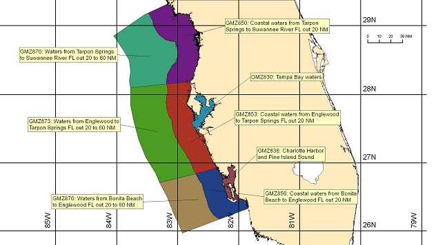
Tampa Bay Marine Forecast: Essential Boating Weather
Understanding the Tampa Bay Marine Forecast: The Forecast Is In
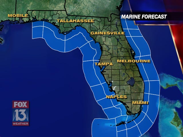
Whether you are planning a weekend fishing trip out in the Gulf of Mexico, sailing across Old Tampa Bay, or taking a paddleboard through the mangrove tunnels of Weedon Island, checking the weather is non-negotiable. When you look up and see that the Tampa Bay marine forecast: the forecast is in, it is time to pay close attention to the details. Local waters can transition from mirror-flat calm to choppy, hazardous conditions in a matter of hours, largely driven by Florida's unique peninsula geography, high humidity, and afternoon sea breezes.
For both seasoned captains and weekend recreational boaters, interpreting marine weather data properly prevents dangerous situations. Beyond simply looking at whether it will rain, a proper marine forecast covers wind speeds, wave heights, water temperatures, and potential small craft advisories. Let us break down how to read these reports and what you need to know before casting off.
Key Elements of Local Marine Weather
When reviewing marine forecasts provided by the National Weather Service (NWS) Ruskin office, you will encounter several specific meteorological terms. Understanding these variables helps you make an informed go/no-go decision for your vessel.
Wind Speed and Direction
Wind is arguably the most critical factor for boaters in Tampa Bay. A brisk 15-knot wind can quickly whip up choppy 2-to-3-foot waves in the shallow waters of the bay, making for an uncomfortable or even dangerous ride in smaller boats. Always note the direction:
- East/Northeast Winds: Often bring drier air and lower water levels in the bay during winter months.
- West/Southwest Winds: Frequently push water toward the coastline, creating higher tides and pushing chop directly into eastern bay shores.
Wave Heights and Period
Wave height tells you how tall the waves are from trough to crest, but wave period (the time in seconds between successive wave crests) is equally important. A short wave period (e.g., 3 to 4 seconds) means steep, closely spaced waves that test your hull and your passengers' stomachs. A longer period indicates smoother, rolling swells.
Visibility and Fog
Tampa Bay experiences heavy fog during the winter and early spring when warm, moist air moves over cooler bay waters. If the marine forecast mentions patchy dense fog, radar and GPS are your best friends, but keeping a sharp visual lookout is mandatory.
Video: Tampa weather | Wednesday morning forecast

Navigating Tampa Bay Hazards
Tampa Bay is a massive estuary covering roughly 400 square miles, but it is notoriously shallow in many areas. Navigating these waters requires respecting local geography and meteorological events.
Afternoon Summer Thunderstorms
From June through September, Florida’s daily sea breeze collisions trigger violent afternoon thunderstorms. These storms pack dangerous cloud-to-water lightning, torrential downpours that reduce visibility to near zero, and sudden microbursts with winds exceeding 40 knots. If the marine forecast calls for scattered to numerous thunderstorms, plan to be off the water by early afternoon.
Tides and Currents
Tidal flow in Tampa Bay can be surprisingly strong, especially around passes like Egmont Key, Boca Ciega Bay, and the Sunshine Skyway Bridge. Strong outgoing tides colliding with opposing winds can create steep, breaking waves at the mouth of the bay. Always check the tide charts alongside your weather briefing.
How to Access Real-Time Marine Data
While the official text forecasts give a broad overview, real-time conditions require checking live observation stations. Relying on a single source is rarely enough when safety is on the line.
Utilize these trusted resources before leaving the dock:
- NOAA Weather Radio: Broadcasts continuous weather information directly from the National Weather Service.
- NDBC Buoy Data: Stations located throughout Tampa Bay and the Gulf provide live wind, wave, and water temperature metrics.
- Mobile Marine Apps: Tools like Windy, Navionics, and local radar apps help track storm cells moving across the peninsula in real-time.
Final Safety Checklist
Before you push away from the slip or ramp, ensure your vessel is prepared for whatever the weather brings. Double-check that your life jackets are accessible, your VHF marine radio is working on Channel 16, and someone ashore knows your float plan. By respecting the Tampa Bay marine forecast and staying vigilant, you ensure that every day on the water ends safely back at the dock.