TDOT SmartWay Traffic Map: Ultimate Driver Guide
Introduction to Tennessee Real-Time Travel

Navigating Tennessee's vast highway network can be unpredictable, whether you are commuting through downtown Nashville or road-tripping across the state on I-40. Unexpected accidents, severe weather, and massive construction zones can turn a routine drive into a frustrating standstill. Fortunately, the Tennessee Department of Transportation provides a powerful public tool to keep motorists informed. By utilizing the TDOT SmartWay traffic map, drivers can access up-to-the-minute data on road conditions before they even turn the ignition.
This comprehensive guide will walk you through how the SmartWay system works, how to read the interactive map, and how to leverage its features to ensure a safe, efficient journey across the Volunteer State.
What is the TDOT SmartWay Traffic Map?
The TDOT SmartWay traffic map is an online, interactive tool managed by the Tennessee Department of Transportation. Its primary goal is to provide real-time information regarding traffic flow, incidents, road construction, and weather-related hazards on Tennessee interstates and state routes.
Instead of relying on delayed radio reports or guessing when an accident might clear, SmartWay pulls data directly from field sensors, highway patrol reports, and state-operated traffic cameras. The platform acts as a centralized dashboard for travelers, commercial truck drivers, and daily commuters who want to outsmart congestion.
Key Features Found on the Map
When you open the TDOT SmartWay traffic map, the interface can look a bit overwhelming at first glance due to the sheer volume of data. However, once you understand the primary data layers, navigating the system becomes second nature. Here are the core features you will find:
Live Traffic Cameras
One of the most valuable assets on the platform is the extensive network of CCTV cameras mounted along major Tennessee corridors. By clicking on the camera icons scattered across the map, drivers can view live, streaming, or frequently refreshed snapshots of current traffic conditions. This allows you to visually verify whether traffic is creeping along slowly or completely gridlocked due to an incident.
Accident and Incident Reports
When crashes, stalled vehicles, or debris block lanes, SmartWay updates almost instantly. Incident markers display specific details about what happened, which lanes are blocked, and emergency response updates. This visibility helps motorists choose alternative routes well in advance.
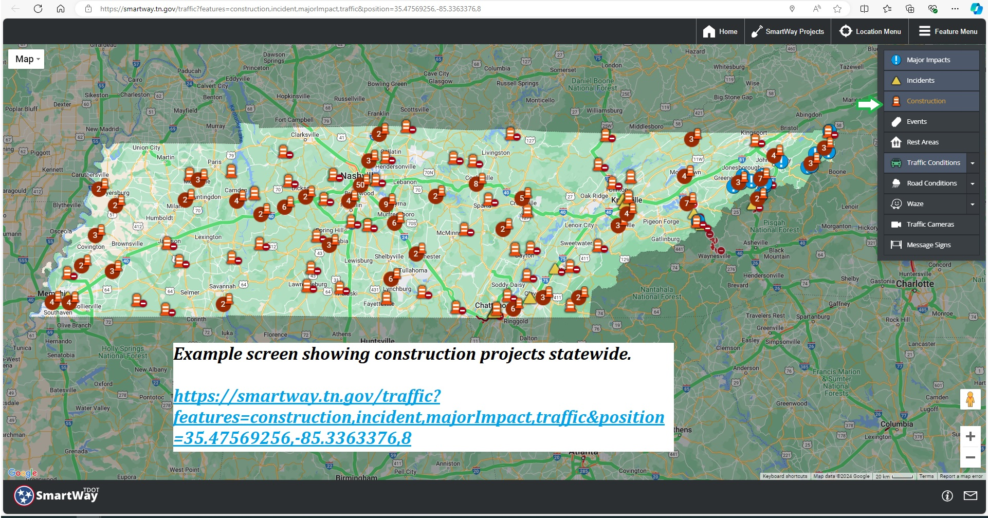
Construction and Maintenance Zones
Video: New SmartWay Features
Tennessee is constantly growing, which means highway expansion and resurfacing projects are a year-round reality. The SmartWay map highlights long-term construction zones as well as temporary lane closures. Knowing where roadwork is happening allows you to factor extra travel time into your schedule or bypass the area entirely.

Dynamic Message Signs (DMS)
The electronic overhead boards you see spanning Tennessee highways are digitally mirrored on the SmartWay map. You can click on these signs to read the exact safety warnings, amber alerts, or travel time estimates currently displayed to drivers on the road.
How to Use the Map Effectively
To get the most out of your experience with the TDOT SmartWay traffic map, keep these practical tips in mind:
- Customize Your View: Use the sidebar menu to turn specific layers on or off. If you only care about cameras and accidents, hide construction icons to reduce visual clutter.
- Check Before You Go: Make checking the map part of your pre-trip routine, especially during peak rush hours in major urban areas like Memphis, Nashville, Knoxville, and Chattanooga.
- Save Favorites: If you commute along the same stretch of highway daily, bookmark specific camera views or zoom levels for quick access.
SmartWay Mobile Access and Apps
Traffic management does not stop when you leave your desktop computer. TDOT offers mobile-friendly solutions so you can access SmartWay data on the go. While you should never look at a smartphone map while actively driving—doing so violates Tennessee hands-free laws—passenger navigators can check the mobile portal easily.
Additionally, TDOT provides audio alerts and integration with major navigation apps. Many modern GPS platforms pull baseline incident data from state DOT feeds, but checking the official SmartWay portal gives you unfiltered, direct-from-the-source information regarding state-managed routes.
Winter Weather and Emergency Preparedness
Tennessee weather can change rapidly, particularly in mountainous East Tennessee and during winter storms. The TDOT SmartWay traffic map becomes an essential lifeline during severe weather events.
During snow and ice storms, the map updates to show:
- Road conditions (e.g., wet, slippery, snow-covered, or impassable).
- The locations and activity status of TDOT snowplows and salt trucks.
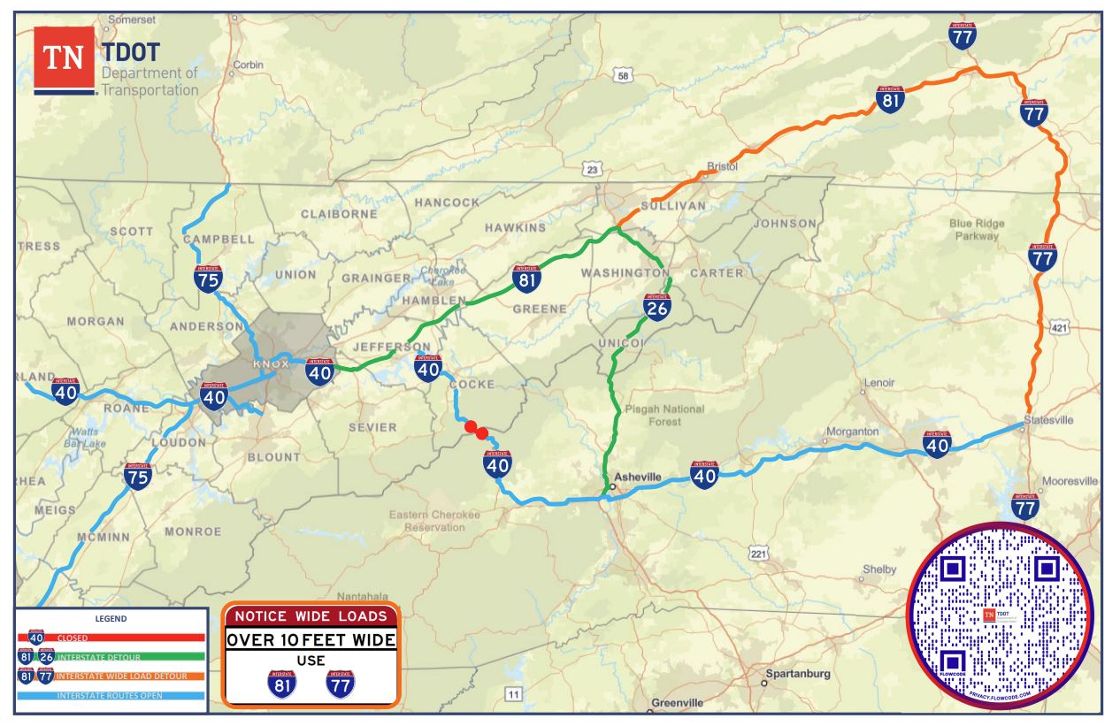
- Emergency closures on mountain passes such as I-40 through the Pigeon River Gorge or I-24 over Monteagle Mountain.
Checking these conditions before attempting to travel through elevated terrain can prevent you from getting stranded in hazardous conditions.
Conclusion
The TDOT SmartWay traffic map is an indispensable tool for anyone driving in Tennessee. By offering real-time insights into accidents, construction delays, live camera feeds, and weather impacts, it empowers drivers to make smarter travel decisions. Take a few minutes to familiarize yourself with the platform's features before your next big trip, and enjoy a safer, more predictable journey across the state.