Uncovering Imperialism Maps Shapes Our Understanding Of Global Power
Maps are frequently treated as objective mirrors of physical reality, yet cartography has always been inextricably linked to political ambition. Today, uncovering imperialism maps shapes our understanding of global power by revealing how colonial empires used spatial representation to legitimize conquest, control resources, and organize human populations. Far from being neutral navigation aids, historical maps operated as declarations of sovereignty, ideological propaganda, and administrative blueprints whose consequences still define modern international relations.

By examining how European powers and other imperial states mapped the globe between the sixteenth and twentieth centuries, historians and political scientists can trace the origins of contemporary border disputes, economic hierarchies, and cultural erasures. Re-evaluating these archival documents transforms how we perceive both past empires and the current geopolitical landscape.
The Cartographic Illusion: How Empires Visualized Dominion
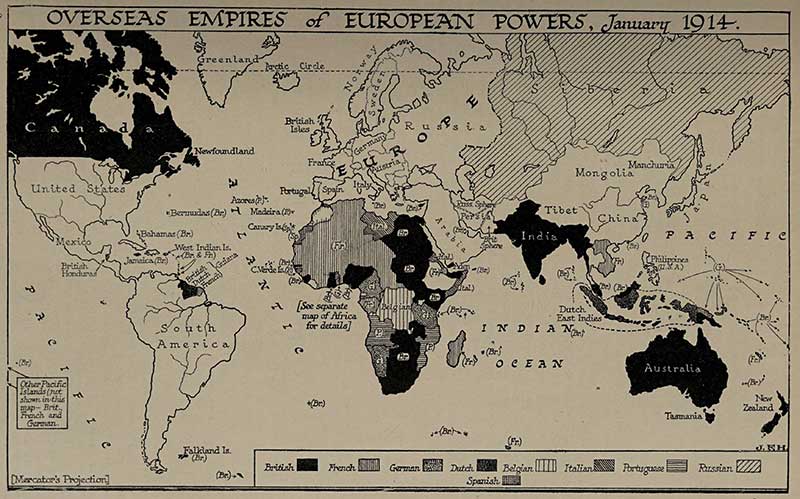
During the age of high imperialism, cartography functioned as an intellectual weapon. European powers did not simply map territories they already ruled; they frequently mapped territories in order to claim them. Drawing a line across a sheet of parchment established an internationally recognized claim among rival empires long before colonial administrators set foot on the ground.
This process relied on deliberate design techniques intended to reinforce imperial superiority:
- Color-Coded Dominance: The iconic practice of coloring British imperial territories in vivid red or pink created an impression of global ubiquity. Walter Crane’s famous 1886 Imperial Federation Map of the World surrounded vast pink landmasses with illustrations of Britannia, Neptune, and indigenous subjects bowing in submission, transforming geography into an imperial tableau.
- Erasure of Indigenous Topographies: Colonizers consistently applied the legal doctrine of terra nullius (nobody’s land) directly onto maps. Indigenous settlements, grazing corridors, sacred sites, and ancient pathways were expunged and replaced by empty grids, inviting European settlement and commercial exploitation.
- Toponymic Hegemony: Renaming geographical landmarks after European monarchs, explorers, and colonial governors served to overwrite local memory and assert cultural ownership over foreign environments.
How Uncovering Imperialism Maps Shapes Our Understanding of Global Power
Modern geopolitics cannot be understood without unpacking the cartographic strategies of the colonial era. When researchers dissect imperial maps today, they uncover the mechanisms by which a handful of Western capitals imposed an enduring structural framework onto the rest of the planet.
The Invention of Artificial Borders
The most visible legacy of imperial cartography is the presence of geometric, straight-line borders. Nowhere was this more destructive than during the 1884–1885 Berlin Conference, where fourteen European states carved up the African continent without consulting a single African leader.
Armed with blank or speculative maps, colonial diplomats drew straight lines through river basins, deserts, and forests. These borders split coherent ethnic, linguistic, and cultural communities while locking historical rivals into shared administrative zones. The modern conflicts in the Sahel, Central Africa, and the Middle East—such as the legacy of the Anglo-French Sykes-Picot Agreement of 1916—demonstrate that imperial cartographers did not merely record borders; they engineered enduring instability.
Projection as Geopolitical Propaganda
Video: How Maps Shape Global Power

Map projections are mathematical compromises, but imperial powers leveraged those compromises for political posturing. The Mercator projection, developed by Gerardus Mercator in 1569 for maritime navigation, preserves angles and shapes at the expense of surface area. Because distortion increases toward the poles, Europe and North America appear disproportionately massive compared to equatorial regions.
Under the Mercator lens, Greenland appears roughly equal in size to the entire continent of Africa, even though Africa is approximately fourteen times larger. For centuries, this visual inflation reinforced the Eurocentric worldview that northern imperial metropoles were the natural geographic, cultural, and political center of gravity.
Resource Extraction and the Logistics of Colonialism
Imperial mapping was not merely about prestige; it was an applied discipline of capital accumulation. The maps commissioned by the British East India Company, the Dutch East India Company, and colonial forestry departments were essentially comprehensive resource audits.
- Geological and Botanical Surveys: Cartographers were tasked with locating mineral deposits, timber reserves, fertile agricultural soils, and navigable waterways to feed the industrial factories of Europe.
- Infrastructure for Extraction: Colonial railway maps reveal a distinctive pattern: rail lines rarely connected domestic population centers to foster regional commerce. Instead, they ran linearly from interior resource nodes directly to deepwater ports designed for export.
- Taxation and Labor Control: Cadastral surveys imposed individual land titling onto societies accustomed to communal land stewardship, turning customary land into taxable, alienable commodities.
Analyzing these resource-centric maps helps explain why contemporary developing nations often struggle with transport networks that point outward toward foreign markets rather than inward toward domestic economic integration.
Decolonizing the Map: The Rise of Counter-Cartography
Because maps played such an active role in colonial subjugation, the movement to decolonize geography has become an essential counterweight in international studies. Scholars, indigenous activists, and digital humanists are using counter-cartography to challenge traditional narratives of global dominance.
Modern counter-cartography takes several forms:
- Indigenous Participatory GIS: Utilizing modern satellite imagery and geographic information systems (GIS) alongside traditional oral histories to map ancestral boundaries, customary land rights, and unceded territories.
- Equal-Area Projections: Promoting map projections such as the Gall-Peters projection or the Equal Earth projection in educational institutions to provide an accurate visual representation of landmass sizes.
- Bottom-Up Urban Mapping: Documenting informal settlements, informal trade networks, and migrant routes that are systematically overlooked by official state cartography.
The Enduring Significance of Spatial Literacy
Power has always resided in the authority to draw the lines that divide humanity. Uncovering imperialism maps shapes our understanding of global power by stripping away the myth that geography is an innocent discipline. Historical maps show that territory is not merely discovered; it is constructed through political will, visual persuasion, and military enforcement.
In an era shaped by debates over territorial sovereignty, maritime boundaries in the South China Sea, and ongoing land claims by indigenous peoples worldwide, interrogating cartographic history is essential. When we read historical maps critically, we cease to view borders as natural facts and recognize them for what they truly are: historical artifacts that can be challenged, rethought, and reformed.