VFR Flight Nav Log Errors to Avoid
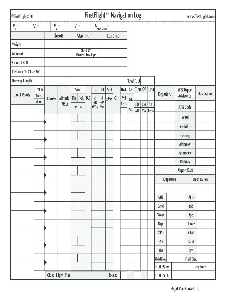
A well-prepared Visual Flight Rules (VFR) navigation log is the backbone of any successful cross-country flight. It guides your dead reckoning, keeps you on schedule, and provides critical data if you ever need to divert or declare an emergency. Yet, many student and private pilots treat the nav log as a tedious paperwork chore rather than a vital operational tool. Rushing through the math or guessing at wind corrections introduces compounding errors that can quickly lead you off course, into restricted airspace, or dangerously low on fuel.

To ensure your next cross-country goes smoothly, it pays to know where pilots most frequently stumble. Let us examine how to avoid these critical errors in your VFR flight nav log entries before you even step foot near the aircraft.
1. Botching Magnetic Variation and Deviation Calculations
One of the most frequent traps in flight planning involves confusing true heading, magnetic heading, and compass heading. Getting these wrong means your aircraft will point in the wrong direction from the moment you lift off.
Forgetting Easterly and Westerly Signs
The golden aviation mnemonic is "East is least, West is best." When converting True Course (TC) to Magnetic Course (MC), you must add westerly variation and subtract easterly variation. Pilots frequently mix up the signs, especially when flying across lines of isogonic variation that shift from east to west. Always double-check your chart's compass roses to confirm your local variation.
Neglecting Compass Deviation
While variation comes from the earth's magnetic field, deviation is caused by the magnetic fields generated by your own aircraft's avionics, engine, and electrical systems. Always consult your aircraft's compass deviation card. Forgetting to apply this final +/- correction can throw your Compass Heading (CH) off by several degrees.
2. Miscalculating Wind Correction Angles (WCA)
Wind is the most dynamic variable in VFR flight planning, and it is where calculations most often unravel.
Using Outdated Weather Data
Wind forecasts change rapidly. Pulling Winds Aloft data that is several hours old—or failing to check winds at your specific cruising altitude—makes your ground speed (GS) and heading calculations pure fiction. Always get the most recent surface observations and upper-wind forecasts.
Forgetting to Apply WCA to Heading
It is surprisingly common for a pilot to calculate a Wind Correction Angle of, say, minus 8 degrees, write it down in the margin, and then completely forget to apply it to their True Course when determining their heading. If the wind is coming from the left, you must crab into it. Failing to apply the WCA ensures you will drift downwind of your checkpoint.
3. Flawed Fuel Burn and Reserve Computations
Running out of fuel is entirely preventable, yet fuel mismanagement remains a leading cause of VFR accidents. Your nav log is your primary defense against coming up short.
Relying on Book Figures Over Real-World Data

POH (Pilot's Operating Handbook) fuel burn charts assume a factory-new engine flying in laboratory conditions. If your aircraft has a pitted prop, a tired engine, or flies slightly out-of-rig, your actual fuel consumption will be higher. Use conservative, real-world fuel burn rates based on your specific aircraft's history.
Failing to Factor in Taxi and Climb Burn
Your cruise fuel burn does not start the moment the engine roars to life. You must account for engine start, taxi, run-up, and the steep climb to your cruise altitude—all of which burn fuel at a much higher rate than level cruise flight. Neglecting these phases means your usable fuel total will be artificially optimistic.
Ignoring FAA Legal Reserves
For daytime VFR flight, the FAA requires enough fuel to fly to your first point of intended landing plus 30 minutes of normal cruise fuel. At night, that requirement bumps up to 45 minutes. Smart pilots calculate these reserves explicitly on their nav log rather than keeping a vague mental tally.
4. Poor Checkpoint Selection
Your checkpoints are the physical milestones that keep your dead reckoning honest. Choosing poor checkpoints guarantees a frustrating flight.
Choosing Indistinct Ground Features
A small farm pond, a patch of woods, or a generic stretch of two-lane highway makes for a terrible checkpoint. In hazy summer visibility, these features blend into the landscape. Select prominent, high-contrast landmarks such as:
- Large towns or cities
- Intersections of major highways or rivers
- Vortacs and airports
- Distinctive shoreline features or mountain passes
Spacing Checkpoints Too Far Apart
If your checkpoints are 60 miles apart, you are flying blind for too long between verifications. If a sudden wind shift pushes you off course near the halfway point, you might not notice until you miss your destination entirely. Aim for checkpoints spaced roughly every 10 to 15 minutes apart, particularly in unfamiliar territory.
5. Skipping Time, Speed, and Distance (TSD) Sanity Checks
Modern electronic flight bags (EFBs) and flight computers make computing time, speed, and distance effortless. However, blindly trusting a digital output without a mental sanity check is a recipe for disaster.
If your EFB tells you that a 40-mile leg will take 12 minutes in a Cessna 172, your internal alarm bells should ring. (At 110 knots ground speed, 40 miles should take roughly 21 minutes). Always perform a quick rough-math estimate before accepting a nav log calculation. If your numbers do not pass the "smell test," re-run the calculation.
Conclusion
A VFR navigation log is much more than a classroom exercise meant to satisfy a Designated Pilot Examiner (DPE) during a checkride. It is a dynamic, practical flight-management tool. By avoiding errors in magnetic variation, wind corrections, fuel burn estimates, checkpoint selection, and math verification, you set yourself up for a safe, low-stress, and thoroughly enjoyable cross-country flight. Take your time during pre-flight planning, question your numbers, and let your nav log work for you.