VFR Flight Navigation Logs Demystified
For many student pilots, staring at a blank navigation log for the first time induces a mild sense of panic. Rows of tiny boxes, magnetic variations, wind correction angles, and fuel burn calculations can make the pre-flight planning sheet look like an advanced calculus exam. However, learning to master VFR flight navigation logs demystified for aspiring pilots is not about memorizing endless formulas; it is about building a reliable roadmap for a safe cross-country journey.

A well-prepared nav log acts as your co-pilot in the cockpit. It keeps you on schedule, ensures you do not run out of fuel, and provides immediate answers when Air Traffic Control asks for your estimated time of arrival at the next checkpoint. This guide breaks down the navigation log into manageable, logical steps so you can plan your next cross-country flight with absolute confidence.
Understanding the Anatomy of a Nav Log
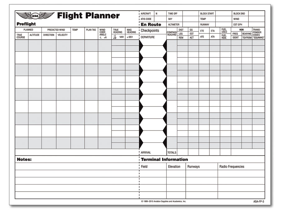
While different flight schools and aviation publishers use varying layouts, almost every standard VFR navigation log contains the same core columns. Breaking these down by section prevents your eyes from glazing over when you sit down at the planning desk.
The Route and Checkpoint Section
Your journey begins by dividing your route into manageable flight legs. You will list your departure airport, prominent visual checkpoints along your course (such as towns, rivers, highways, or VOR stations), and your destination.
- Checkpoint: Specific, easily identifiable landmarks on your sectional chart.
- True Course (TC): The actual direction of your flight path measured over the earth's surface from true north.
Wind Correction and Headings
Airplanes rarely fly in a straight line relative to the ground when the wind is blowing. This section of the log helps you adjust for the elements.
- Magnetic Variation (MV): The angular difference between true north and magnetic north, found on your sectional chart via isogonic lines.
- Wind Correction Angle (WCA): The degrees you must steer into the wind to maintain your desired ground track.
- True Heading (TH): True course adjusted for the wind correction angle.
- Magnetic Heading (MH): True heading adjusted for magnetic variation. This is the number you will ultimately look at on your directional gyro or magnetic compass.
Time, Speed, and Distance
This is where you figure out how long each leg will take and how much fuel you will burn. You will use your E6B flight computer (mechanical or electronic) to fill in these critical operational figures.
- Groundspeed (GS): How fast your aircraft is moving across the ground, factoring in headwind or tailwind components.
- Distance (DIST): The length of the leg in nautical miles.
- Estimated Time Enroute (ETE): The time it takes to fly a specific leg, calculated by dividing distance by groundspeed.
- Fuel Burn: The expected gallons consumed per leg, based on your aircraft's performance charts.
Step-by-Step Guide to Filling Out Your Log
Planning a cross-country flight is a sequential process. Rushing ahead or skipping steps usually leads to errors that compound over the course of a long flight.
Step 1: Draw and Measure Your Course
Lay your VFR sectional chart flat on a table. Draw a straight line from your departure airport to your destination, avoiding restricted airspace, prohibited areas, and high obstacles. Select checkpoints roughly every 10 to 15 miles, or at prominent geographical features. Use your plotter to measure the True Course for each leg and write it down in the log.
Video: VFR Cross Country Flight Planning
Step 2: Gather Weather and Calculate Winds
Obtain a comprehensive weather briefing. Find the winds aloft forecast for your planned cruising altitude. Using your E6B, input your True Airspeed (TAS), forecasted wind direction, wind speed, and True Course. The E6B will output your Wind Correction Angle and your expected Groundspeed. Transfer these numbers directly to your nav log.
Step 3: Compute Headings and Times
Apply magnetic variation to your True Heading to find your Magnetic Heading (Remember the old aviation rule: "East is least, West is best" when applying variation to true north). Next, calculate the ETE for each leg. If a leg is 30 nautical miles and your groundspeed is 100 knots, your ETE is 18 minutes (30 / 100 * 60).
Step 4: Total Your Fuel and Time
Add up the ETEs of all your legs to find your total time enroute (TTE). Add extra time for taxi, takeoff, climb, and a minimum VFR regulatory reserve (30 minutes for day VFR, 45 minutes for night VFR). Multiply your total flight time by your hourly fuel burn rate to ensure you have more than enough fuel in the tanks.
In-Flight Execution: Using the Log in the Cockpit
Filling out the log on the ground is only half the battle. In the cockpit, the navigation log becomes a dynamic tool that requires active management.
The "ACT" Method for Checkpoints
As you cross each pre-planned checkpoint, perform three quick actions:
- Actual Time: Write down the exact Zulu time you passed the checkpoint in the "Actual Time Enroute" column.
- Actual Fuel: Cross-reference your fuel gauges or fuel totalizer against your planned fuel remaining.
- Recalculate: Compare your actual time to your estimated time. If you are more than a couple of minutes off, recalculate your groundspeed and update your ETA for the subsequent legs.
By maintaining this disciplined rhythm in the cockpit, you eliminate guesswork. If Air Traffic Control asks for your position or ETA, you can provide an accurate answer instantly rather than fumbling through a mental calculation.
Common Pitfalls to Avoid
Even experienced pilots occasionally make simple math errors during flight planning. Watch out for these common navigation log traps:
- Forgetting Variation Signs: Adding instead of subtracting magnetic variation (or vice versa) will point you in entirely the wrong direction. Double-check your compass math.
- Ignoring Fuel Reserves: Never plan a flight that cuts into your legal fuel reserve. Always build in a safety buffer for unexpected headwinds or diversions.
- Cluttering the Log: Keep your handwriting legible. If you change your flight plan mid-air due to weather, use a blank space or the back of the log rather than writing over old numbers and confusing yourself.
Ultimately, a VFR navigation log is more than a regulatory requirement or a flight school checklist item. It is the tangible embodiment of your pilot-in-command responsibility. Take your time during pre-flight planning, trust your calculations, and let your nav log guide you safely to your destination.


