Weather Underground Longmont: Hyper-Local Guide
Living along Colorado’s northern Front Range means accepting that a forecast for an entire county rarely tells the whole story. If you rely on weather underground longmont data, you already know that conditions can swing wildly between the St. Vrain Creek greenway, the Vance Brand Airport on the west side, and the agricultural plains stretching east toward Weld County. A single afternoon can bring pea-sized hail to Old Town while neighborhoods near McIntosh Lake remain completely dry.
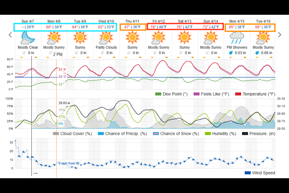
Weather Underground remains one of the most effective tools for decoding these hyper-local variations. By crowdsourcing meteorological data from hundreds of Personal Weather Stations (PWS) mounted in backyards, schools, and local businesses, the platform offers street-level precision that single-station airport reports simply cannot match.
Why Longmont’s Microclimates Require Hyper-Local Data
Longmont sits in a geographic sweet spot that makes weather forecasting notoriously complex. Resting at an elevation of roughly 4,984 feet in the St. Vrain Valley, the city is bounded by the foothills of the Rocky Mountains directly to the west and the high plains to the east. This topography creates localized weather drivers that standard regional models often smooth over.
The Valley Inversion Effect
Cold air is dense and heavy. During calm winter and autumn nights, cold air drains down the St. Vrain basin and pools in low-lying Longmont neighborhoods. While elevated areas like Fox Hill or southwest ridges near Niwot stay several degrees warmer, low pockets near the river bottom experience sharp temperature drops. Weather Underground stations placed throughout these low zones often reveal localized hard freezes hours before official city forecasts predict them.
Upslope vs. Downslope Wind Dynamics
When moist air masses track from the north or east, they hit the foothills and are forced upward—a phenomenon known as upslope flow. This is the engine behind Longmont’s biggest snowstorms. Conversely, westerly winds spilling down from the Continental Divide compress and warm up, creating dry, gusty Chinook winds. These winds can raise temperatures by 30 degrees in a couple of hours while devastating local humidity levels, drastically increasing fire danger in western Longmont.
Using Weather Underground Longmont for Neighborhood Accuracy
Official meteorological observations for Longmont originate from the automated surface observing system at Vance Brand Airport (KLMO). While accurate for aviation, conditions on an open runway asphalt apron often differ significantly from residential neighborhoods shaded by mature cottonwoods and maples.
Weather Underground bridges this gap by aggregating neighborhood-specific PWS nodes. Here is what to look for when navigating local stations across the city:
- Old Town and Downtown: Characterized by an established urban canopy and older brick structures, these stations frequently reflect an urban heat island effect, recording nighttime lows 2 to 4 degrees warmer than outlying areas.
- McIntosh Lake and Northwest: Closer to the foothills, these stations are prime monitors for the first gusts of downslope winds and early precipitation spilling over the foothills from Lyons.
- Southwest / Hover Corridor: Useful for tracking storm cells pushing north from Boulder along Highway 119.
- East Longmont (County Line Road / Weld County border): Transitioning into agricultural prairie, these stations capture wider diurnal temperature spreads, stronger winds unobstructed by trees, and the western fringes of dryline thunderstorm development.
Best Features on Weather Underground for Front Range Residents
To get the most out of the platform beyond checking whether to grab a jacket, take advantage of the specific analytical tools built into Weather Underground.
WunderMap with Radar Overlay
WunderMap is the platform’s interactive mapping interface. During spring severe weather season, standard radar can show an intimidating cell over Boulder County, but overlaying live PWS readings allows you to see whether temperatures ahead of the storm are supportive of snow, rain, or severe hail. You can track real-time wind gusts across town to anticipate when a gust front will reach your neighborhood.
Historical Weather Data
Longmont gardeners and landscapers frequently use the platform’s historical records. If you are timing the spring planting of cool-season crops or winterizing your sprinkler system, you can inspect historical freeze dates for your specific neighborhood rather than relying on generalized regional averages.
Precipitation Rate and Accumulation
Rain gauges on individual weather stations report rainfall rates in real time. Following a heavy summer thunderstorm, this helps determine whether a downpour dropped a half-inch of localized, flood-inducing rain on your street or merely settled the dust.
Navigating Longmont’s Seasons with Local Weather Data
Spring: Thunderstorms, Rapid Freezes, and Hail
Spring in Longmont (late March through early June) brings violent weather transitions. A sunny 75-degree morning can devolve into an afternoon severe thunderstorm producing large hail and damaging downburst winds. Checking barometric pressure trends on local PWS stations provides early warning of fast-dropping pressure troughs before thunder echoes off the foothills.
Summer: High Heat and Ozone Alerts
Summer days frequently reach into the mid-90s. Due to terrain trapping, ground-level ozone can accumulate in the St. Vrain Valley during prolonged stagnant heatwaves. Neighborhood weather stations paired with air quality monitors (such as PurpleAir integration) help outdoor enthusiasts decide whether an afternoon run around Union Reservoir is healthy.
Fall: Crisp Transitions and Early Freezes
Autumn is generally Longmont’s most stable season, but early Arctic cold fronts can dive down from Canada as early as September. Local frost warnings rely heavily on low-elevation valley stations where the frost forms first.
Winter: Micro-Scale Snow Accumulation
Winter storms along the Front Range are infamous for sharp snowfall gradients. A storm track shifting just ten miles can mean 14 inches of heavy powder in Hygiene and western Longmont, but only 4 inches out toward I-25. Tracking active snow-water equivalent and temperature readings across multiple local stations helps you plan commutes along Highway 287 or the Diagonal Highway.
How to Select a Reliable Longmont PWS
Because anyone can purchase a weather station and connect it to Weather Underground, data quality can vary. A station mounted next to an air conditioning condenser or on a hot asphalt roof will report skewed temperatures. To ensure you are viewing reliable data:
- Check for Station Verification: Look for the gold or blue checkmarks on the station profile, which indicate that the station’s readings pass Weather Underground’s quality control algorithms against neighboring hardware.
- Cross-Check Neighbors: If one station in Somerset Meadows reports 82°F while three surrounding stations report 74°F, the hot station is likely suffering from radiant heat interference or poor siting.
- Look for Davis Instruments or Ambient Weather Hardware: Stations utilizing commercial-grade hardware typically feature better-shielded solar radiation sensors and more reliable anemometers.
Connecting Your Own Station to the Network
If you live in a pocket of Longmont with sparse coverage—such as newly developed subdivisions on the east side or rural parcels along the St. Vrain—setting up your own PWS connects your backyard directly to the global network. Mount your sensor array at least five feet above grass, away from structures and reflective fences, and keep the rain gauge clear of overhanging trees. Once registered, your backyard becomes a vital data point helping neighbors, commuters, and meteorologists understand Longmont’s ever-changing sky.